TIMING: Thursday 9 pm – Friday
In-Depth:
Numerous rounds of slow-moving showers and heavy thunderstorms have already impacted Middle Tennessee and Southern Kentucky. Additional heavy downpours are expected tonight through Friday. Especially during the overnight hours.
Our flash flood threat has increased because the ground is already saturated. Any additional heavy rain will quickly run off into creeks, streams, and low-lying areas, increasing the risk of flash flooding.
A Flood Watch goes into effect at 1:00 PM today and continues through Sunday.
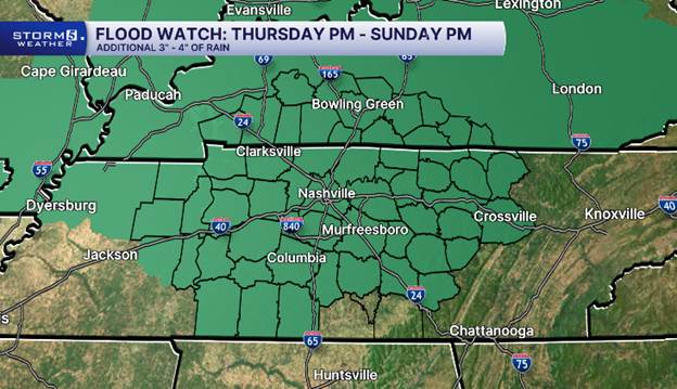
Currently, our STORM 5 ALERT is in effect from 8:00 PM tonight (Thursday) through Friday. We will continue to closely monitor conditions and determine whether the STORM 5 ALERT needs to be extended through the weekend.
In addition to flash flooding, damaging wind gusts are also a concern. The Storm Prediction Center has also placed our area under a Level 1 of 5 severe weather risk. While flooding remains the primary concern, a few storms could also produce damaging wind gusts. Combined with saturated ground, those stronger winds could more easily uproot trees.

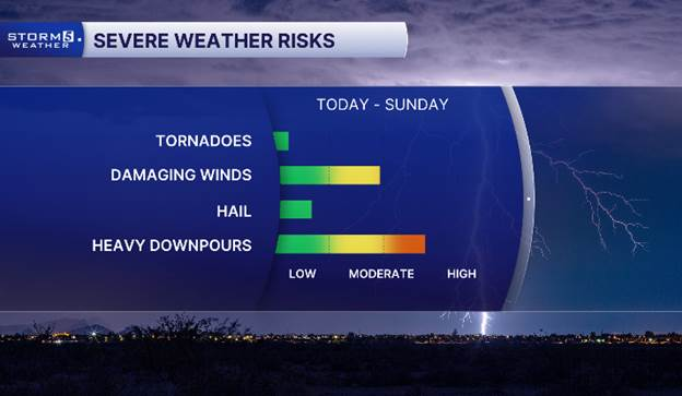
Threats with these storms include localized flash flooding, damaging wind gusts, and frequent lightning.
Stay tuned to the Storm 5 Weather team for the latest updates on timing and severe threats that could impact your Thursday Night & Friday.
-
The NewsChannel 5 App – get alerts right to your phone, based on your location.
-
Storm 5 WeatherCall – our subscription-based service that calls your phone when your address is in a warning.

Kelsey Gibbs brings us a powerful story of humanity, compassion, and love in action while showing us the hard and lifesaving work our officers do daily. Nashville is lucky to have people like Lt. Hotz wearing the badge.
- Carrie Sharp