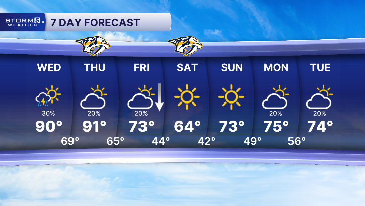
Mid-90s to Patchy Frost: Weather Whiplash Ahead
Forecast:
Today: Partly Cloudy w/ Iso. Shower & T-Storms Poss. in the Afternoon | High: 90 | SW 5-10
Tonight: Mostly Cloudy |Low: 68| SSW-5
In Depth:
Record warmth continues today and tomorrow, with afternoon highs expected to climb into the upper 80s to low 90s.

Much-needed chances for rain return today as a disturbance moves through the Mid-South. However, we’re not anticipating widespread rainfall.

Locations to the northwest look to be the most favored, as the system moves southeast and begins to break apart.

Big changes arrive Friday as a cold front moves into Middle Tennessee and Southern Kentucky. This system looks to be moisture-starved, so rain chances will remain around 20%.

However, the wind will be strong, and temperatures will tumble. With gusty winds, it will feel even colder!

By Saturday morning, some areas will feel as though temperatures are in the 30s.

Winds will decrease overnight into Sunday, and with clear skies, temperatures will tumble into the upper 30s to low 40s. This will bring our first chance for patchy frost of the season, especially for those along the Plateau.